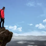
Imagine driving the iconic Pacific Coast Highway. Big Sur offers dramatic cliffs and breathtaking ocean views. This 90-mile scenic drive along California Highway 1 promises unforgettable sights. Over six million visitors come to Big Sur each year. You will experience the stunning California coastline and the rugged Big Sur coastline. This guide helps you plan your ultimate Big Sur road trip. Prepare for an epic road trip adventure in California.
Key Takeaways
Plan your Big Sur trip for September or October. The weather is good and there are fewer people.
Drive from north to south on Highway 1. This gives you the best ocean views.
Cell service is poor in Big Sur. Download maps and guides before you go.
Book your places to stay early. There are not many options, and they fill up fast.
Drive carefully on the winding roads. Watch for wildlife and check road conditions often.
Planning Your Big Sur Road Trip
Planning your Big Sur road trip ensures a smooth and memorable adventure. You will experience the stunning 90-mile scenic drive along California Highway 1. Proper planning helps you make the most of your time in this beautiful part of California.
Best Time to Visit Big Sur
You will find September through October the best time to visit Big Sur. The weather is typically warmest then. Daytime temperatures reach the mid-70s in early fall. They drop to the low 70s later in the season. Coastal fog is usually less common. This means you get improved visibility. Fall is excellent for photographers and hikers. You will enjoy mild temperatures, perfect for outdoor activities. You also see fewer tourists during this period.
Trip Duration Recommendations
Plan about a week for your Big Sur road trip. This allows you to explore fully. You can stop at every single viewpoint. A Big Sur day trip is possible. However, a multi-day road trip gives you more time. You can truly experience the area. This comprehensive Big Sur itinerary lets you discover hidden gems.
North to South Direction Benefits
Drive the Pacific Coast Highway from north to south. This keeps your car in the lane closest to the ocean. You get an unobstructed view of the cliffs. This orientation provides a more enjoyable experience of the coastal sights. Start your journey in Monterey or Carmel-by-the-Sea. This is how to get to Big Sur with the best views.
Big Sur Packing List
Pack smart for your Big Sur adventure. You will need good walking shoes for hiking. Bring swim gear for beach stops. A light jacket or sweatshirt is useful for cool evenings. Consider a rain jacket and warm pants for spring visits. For fine dining, pack a semi-fancy outfit. Binoculars enhance your sightseeing. Travel apps like Google Maps help you navigate California Highway 1. A small cooler is great for summer snacks.
Navigating the Pacific Coast Highway
You will find navigating the Pacific Coast Highway a unique experience. This scenic route requires some preparation. Understanding road conditions, cell service, and fuel stops ensures a smooth trip.
Road Conditions and Closures
Road conditions on California Highway 1 can change quickly. Landslides or weather sometimes cause closures. Always check for updates before you start your drive. You can use several resources for real-time information:
QuickMap: This resource provides real-time traffic information for the State highway system. You can also get the QuickMap Mobile app for on-the-go access.
Caltrans Road Information: This site offers current highway conditions. You can enter highway numbers or call 1-800-427-7623 for updates.
CHP Traffic Incident Information Page: This page gives you real-time traffic incident data.
These tools help you stay informed about any full closures.
Cell Service and Navigation
Cell service is very limited along much of California Highway 1. You will likely lose signal in many areas. Relying on your phone for live navigation is not a good idea. Plan ahead for your navigation needs:
Download the Guide Along App: This app offers navigation assistance. It also shares stories, history, and insights into Big Sur’s best sights.
Download The Ultimate Big Sur Road Trip Guide: Having a downloaded guide ensures you do not miss any desired locations.
Utilize The Ultimate Big Sur Road Trip Map: Share the map to your email. Open it on your phone for mobile access to navigation without service.
These steps ensure you can find your way through the best sections of pacific coast highway.
Fuel Stops
Fuel stations are scarce in Big Sur. You should fill your gas tank before you enter the area. Prices for gas are also higher here. Plan your fuel stops carefully. You will find a few options:
Three gas stations are located in the village of Big Sur.
One handy gas station is available at Ripplewood Resort.
Make sure you have enough fuel to enjoy your drive through this beautiful part of California.
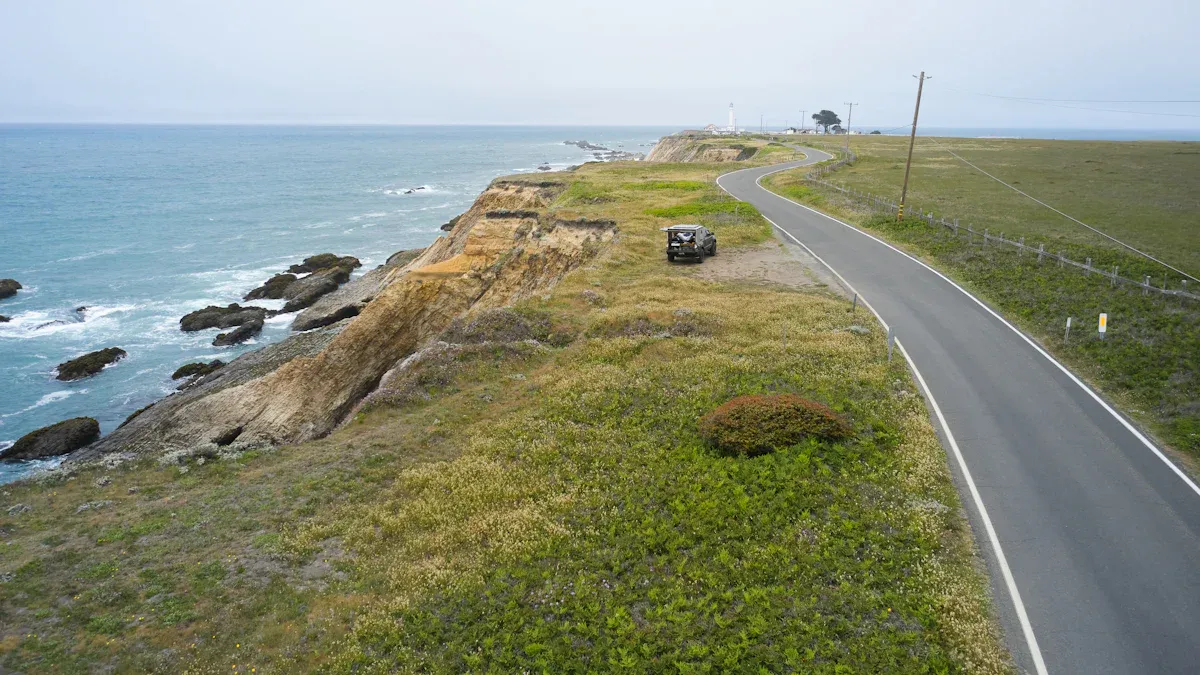
Big Sur Scenic Views
You will discover many breathtaking sights along the Big Sur coastline. This region offers diverse attractions. You can explore towering redwood groves, dramatic coastal bluffs, and unique waterfalls. The area also features a purple sand beach. Big Sur’s coastal landscape is geologically diverse. It features high cliffs and rugged canyons. This area is prone to landslides and debris flows, which shape its dramatic appearance. These are some of the must see stops on your journey.
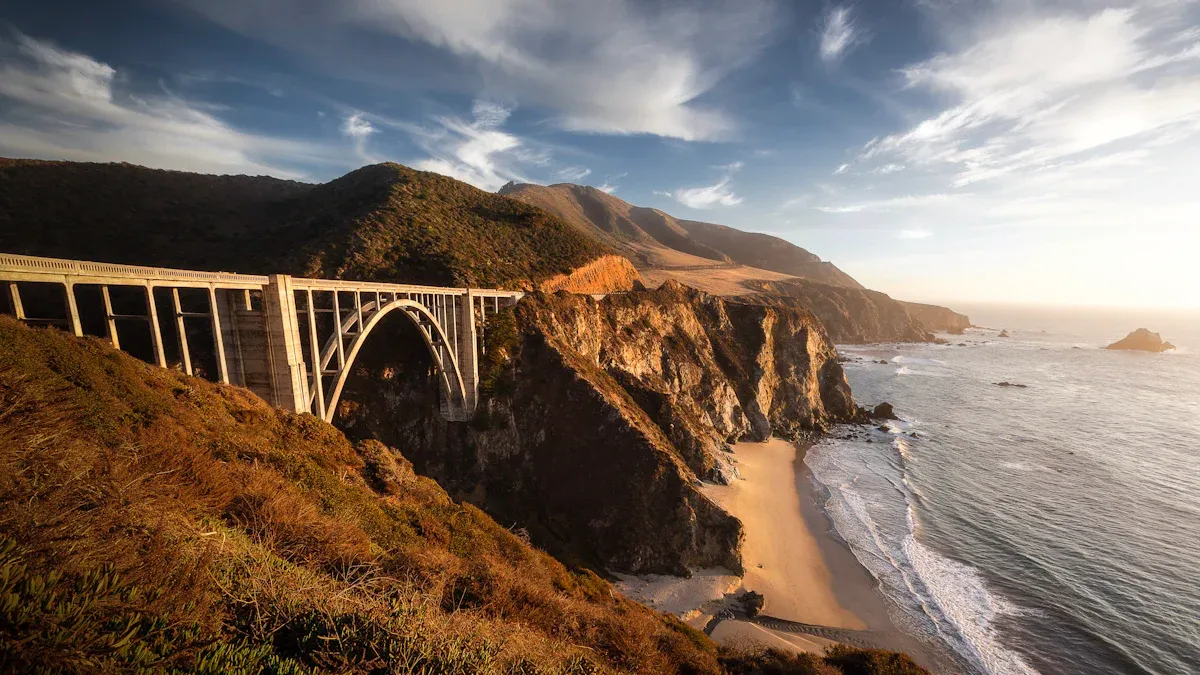
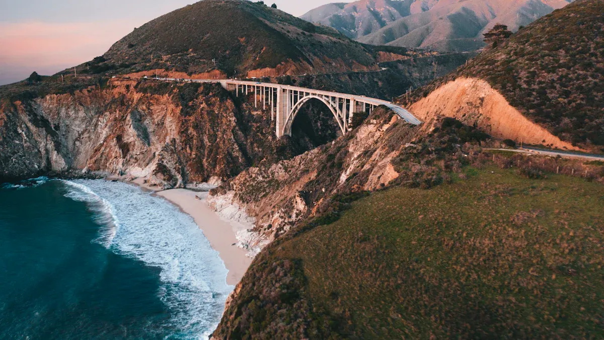
Bixby Bridge
You will find Bixby Bridge one of California’s most famous landmarks. This bridge is a highly photographed spot on the West Coast. It often appears on postcards and in TV advertisements. The Bixby Bridge serves as a gateway to Big Sur. This area is known for its pristine land and spectacular meeting of ocean and land. The bridge itself is a reinforced concrete open-spandrel arch bridge. Its design is both aesthetic and graceful. You will notice its parabolic arch shape, tall spandrel columns, and architectural piers. These features create an intense aesthetic experience. Builders chose concrete during the Depression. This choice reduced material costs and provided jobs. It also helped the Bixby Bridge blend with the natural rock formations.
McWay Falls
McWay Falls offers a truly unique sight. This 80-foot waterfall cascades down a cliff face. It lands directly on the sand, feeding into the ocean. This makes McWay Falls a tidefall. This is a rare phenomenon. You will find very few such features on the entire continent of North America. You can view this beautiful mcway waterfall from an overlook.
Pfeiffer Big Sur State Park
You can explore Pfeiffer Big Sur State Park. This park offers many attractions and hiking opportunities. You can see the Colonial Tree. It is the largest tree in the park. It stands 277 feet tall and measures 31 feet in diameter. Experts estimate it is over 1200 years old. You can also visit the Homestead Cabin. John Pfeiffer built this cabin in the late 1800s. It is one of the oldest structures in the region. The Ewoldsen Memorial Nature Center teaches you about local plants and animals. It even has a digital condor flight station. You can also visit the Big Sur River Gorge. This area features large granite formations.
You will find many trails for hiking. The Valley View & Pfeiffer Falls Trails offer a 2-mile hike. You get views of the Big Sur River Valley and Point Sur. A spur trail leads to the 60-foot Pfeiffer Falls waterfall. The Nature Trail & River Path Loop is an easy, family-friendly hike. It takes you through towering coastal redwoods. You can also walk along the Big Sur River. For a challenge, try the Mt. Manuel Trail. It is an 8-mile round trip hike. The Buzzard’s Roost Trail gives you panoramic ocean views.
Garrapata State Park
Garrapata State Park showcases Big Sur’s wild beauty. You will see massive rugged cliffs and endless ocean views. East of California Highway 1, the park has wilderness areas. These include canyons, redwood groves, and tall mountains. Garrapata State Beach is a long, sandy, crescent-shaped beach. It has rugged Big Sur cliffs, sea stacks, and seasonal wildflowers. You can access it via stairs at mile marker 19. At low tide, you can reach Garrapata Creek Cove. This small, secluded cove features a cave.
During spring, you might see a wildflower superbloom. This happens especially around Soberanes Point. The park becomes a canvas of vibrant colors. You can also spot sea otters in the coastal waters. They play and feed there. Tide pools reveal diverse marine life during low tide. You might see sea stars, anemones, and crabs. The dramatic cliffs are perfect for birdwatching. Soberanes Point offers stunning views of the Pacific Ocean. It is popular for photography and whale watching. You can explore tide pools and observe marine life on its trails.
Point Lobos State Reserve
Point Lobos State Reserve is a jewel on the California coastline. It offers beautiful coastal views and tide pools. You will find many photography opportunities here. Highlights include the Cypress Grove Trail and Sea Lion Point. China Cove is also popular for photos. The reserve has extensive kelp forests and underwater pinnacles. You can also find submarine caverns.
You will see abundant marine wildlife. You might hear sea lions barking. You can spot whales year-round near Sea Lion Rock. Harbor seals and sea otters are also common. In spring, you might see seal pups in China Cove. Tide pools at Weston Beach reveal hermit crabs and sea anemones. The reserve also features dramatic coastal formations. You will see vibrant ocean colors and iconic Monterey cypress trees. The Carmel submarine canyon brings cold, nutrient-rich water. This fuels high primary productivity. This makes Point Lobos a rich ecosystem.
Rocky Point Overlook
You can stop at Rocky Point Overlook for another stunning vista. This spot provides expansive views of the Pacific Ocean. You will see the rugged coastline stretching out before you. It is a great place to pull over and take photos.
Hurricane Point
Hurricane Point offers dramatic views of the Big Sur coastline. The wind often blows strongly here. This adds to the wild feeling of the place. You get a sweeping panorama of the ocean and cliffs. It is an excellent spot for sightseeing and appreciating the vastness of the Pacific.
Your Ultimate Road Trip Itinerary: Key Big Sur Stops
You are ready to explore the heart of Big Sur. This section guides you through the must see stops on your ultimate Big Sur itinerary. Each stop offers a unique experience. You will discover why this big sur road trip is a dream for many travelers.
17-Mile Drive
Start your adventure with the famous 17-Mile Drive. This scenic route is a pre-Big Sur experience. It winds through Pebble Beach and Pacific Grove. You pay a small fee to enter. You will see stunning coastal views and famous landmarks. Look for China Rock, a great spot for wide-angle photos. Bird Rock is a wildlife hub. You can spot seals, sea lions, and many birds there. Seal Rock features a large sandy beach and tidepools. Fanshell Beach Overlook gives you beautiful views of the beach. Cypress Point Lookout offers scenic vistas. The Crocker Grove contains the largest and oldest Monterey Cypress trees. The Lone Cypress is a famous, 250-year-old tree. It is a symbol of Pebble Beach. Ghost Trees at Pescadero Point show unique sun-bleached trees. This spot is also a legendary big wave surf spot. You can also visit the Pebble Beach Visitor Center to learn about the area’s history. This drive sets the stage for your big sur road trip.
Carmel-by-the-Sea
Next, you will arrive in Carmel-by-the-Sea. This charming town is known for its unique architecture and art scene. You will find nearly 100 art galleries here. They showcase diverse artistic expressions. You can explore various styles and meet artists. The central village is car-free and very walkable. Cobblestone streets lead you to shops, galleries, and cafes. You can immerse yourself in its charming atmosphere on foot. Look for the “fairy tale” cottages. Artist Hugh Comstock designed these homes. They have high-pitched roofs and wood shingles. Other homes show Mediterranean influences with red tile roofs. Some are contemporary with sleek lines and large windows. This town offers a delightful break from driving.
Pfeiffer Beach (Purple Sand)
You must visit Pfeiffer Beach. It is famous for its unique purple sand. This distinctive color comes from nearby mountains. These mountains have many mineral deposits. Specifically, they contain manganese garnet, a purplish silicate. Local rainfall washes fine crystals of this manganese garnet down to the seashore. This process gives the beach its natural purple hue. The color is most vibrant in winter. It looks even better after seasonal storms moisten the sand. Pfeiffer State Beach is a truly unique sight on your big sur itinerary.
Nepenthe Restaurant
Stop at Nepenthe Restaurant for an unforgettable dining experience. This cliffside restaurant offers panoramic ocean views. You can enjoy these views from a spacious viewing terrace. You do not even need to dine to appreciate the scenery. Bill and Lolly Fassett founded Nepenthe in 1949. The name means “that which puts an end to sorrow.” The mythical Phoenix bird is its logo. The restaurant became famous even before it opened. It appeared in Architectural Digest. Nepenthe offers a relaxed atmosphere. It welcomes everyone from Bohemians to Hollywood celebrities. You can also visit Café Kevah. It is part of the Nepenthe property. Café Kevah offers a Mediterranean-focused brunch. It has an open-air patio and gourmet coffees. You can also find The Phoenix Shop here.
Henry Miller Library
You will find the Henry Miller Library a unique cultural stop. This cherished spot functions as a bookstore. It also serves as a venue for performances. It is a cultural center dedicated to the author Henry Miller. The library encourages visitor donations. It contributes to the area’s artistic ambiance. You can also find COAST Big Sur nearby. This converted water tank is an art gallery. It features rotating exhibits. It also has a rooftop cafe with ocean views. These spots highlight the rich cultural side of big sur.
Limekiln State Park
Explore Limekiln State Park. This park offers beautiful redwood groves. You can also see historic lime kilns. These kilns stand as reminders of the area’s industrial past. You can hike through the redwoods. You can also enjoy the small beach. It is a peaceful stop on your california highway 1 journey.
Ragged Point
Ragged Point marks the southern gateway to Big Sur. It offers dramatic panoramic views of the coastline. You can see the rugged cliffs and the vast Pacific Ocean. It is a perfect spot to stretch your legs. You can also take some final photos of the stunning big sur scenery.
Piedras Blancas Elephant Seals
Your big sur road trip continues to Piedras Blancas. Here, you can observe a large colony of elephant seals. The Piedras Blancas rookery is home to about 17,000 elephant seals. You can see them sunbathing, fighting, and sleeping. The population on the beach peaks in October. Juvenile male and female seals arrive for their fall haul-out then. This creates another peak viewing period. You can visit the 140-year-old historic Piedras Blancas Light Station. You need tickets online in advance for a tour. Or, you can take a virtual tour. Just down the road, you can watch the elephant seals at the Vista Point. This is a truly wild and memorable stop on your california road trip.
Big Sur Accommodations
Finding where to stay in Big Sur requires careful planning. This beautiful stretch of California offers limited options. You must book your lodging well in advance. This ensures you have a comfortable place to rest after exploring the stunning coastline.
Hotels and Resorts
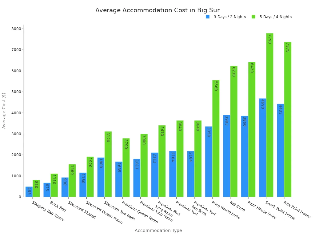
Big Sur has various hotels and resorts. They range from rustic to luxurious. You will find different price points depending on your choice. Here is a look at the average costs for various accommodation types for different stay durations. This helps you plan your budget for where to stay.
Accommodation Type | 3 Days / 2 Nights (Cost Range) | 5 Days / 4 Nights (Cost Range) |
|---|---|---|
Sleeping Bag Space | $430 – $560 | $680 – $940 |
Bunk Bed | $610 – $740 | $980 – $1240 |
Standard Shared | $930 | $1560 |
Standard Queen Room | $1,090 – $1,230 | $1,780 – $2,060 |
Standard Two Beds | $1,810 – $1,950 | $2,980 – $3,260 |
Premium Queen Room | $1,570 – $1,800 | $2,580 – $3,000 |
Premium King Room | $1,690 – $1,932 | $2,780 – $3,220 |
Premium Plus King Room | $2,040 – $2,184 | $3,180 – $3,640 |
Premium Yurt | $2,184 | $3,640 |
Premium Yurt Two Beds | $2,184 | $3,640 |
Price House Suite | $2,540 – $4,176 | $4,160 – $6,960 |
Rolf Suite | $3,630 – $4,176 | $5,500 – $6,960 |
Point House Suite | $3,790 – $3,930 | $6,280 – $6,560 |
South Point House | $4,690 | $7,790 |
Fritz Point House | $4,176 – $4,690 | $6,960 – $7,790 |
Camping and Glamping
You can also choose camping or glamping. These options let you experience nature more closely. Many state parks and private campgrounds offer sites. Glamping provides a more luxurious outdoor experience. You get comforts like beds and private bathrooms.
Advance Booking Tips
You must book your Big Sur accommodations far in advance. This is especially true during peak seasons. Weekend trips also fill up quickly. The unique charm and limited choices mean places get reserved fast. Plan ahead to secure your ideal spot for where to stay in this part of California.
Big Sur Dining
You will find dining options in Big Sur are limited. Prices can also be higher. However, you have some unique choices.
Eateries and Cafes
Nepenthe offers an authentic experience. You get great views and fire pits there. Cell reception is often absent. Try their famous Ambrosia burger. Nepenthe does not take reservations. It can get busy on summer weekends. River Inn is a spot to relax by the river. They are known for mojitos. It is also kid-friendly. Food quality is not always highly recommended. Tree Bones Resort offers a 13-course prefixed sushi dinner. You need a reservation for this. Sushi Jawn is a pop-up sushi van. Big Sur Tap House features a backyard patio. It is good for beer and board games. Deetjens has some of the best food. Their stuffed French toast is legendary. Always check their operating hours.
Picnic Spots
You might want to pack your own meals. This saves you money. It also gives you flexibility. Many beautiful places in California offer a perfect picnic spot. Look for scenic overlooks along the Pacific Coast Highway. Many state parks also provide picnic tables. You can enjoy your food with stunning views.
Grocery Stores
You should plan your grocery stops carefully. The Fernwood Big Sur General Store is a convenient option. It is located at 47200 CA-1, Big Sur, CA 93920. This store operates from 8 AM to 10 PM. It offers a mini-market with groceries. You can find fresh produce, dry goods, and snacks. They also have frozen meals. Camping and RV supplies are available. For larger grocery runs, you can visit Safeway stores outside the main area. Safeway Del Rey Oaks is at 815 Canyon Del Rey Blvd, Del Rey Oaks, CA 93940. It opens from 5:00 AM to 2:00 AM daily. Safeway Pacific Grove is at 1212 Forest Ave, Pacific Grove, CA 93950. It also opens from 5:00 AM to 2:00 AM daily. Safeway Carmel (Crossroads Blvd) is at 5 Crossroads Blvd, Carmel, CA 93923. This store is open 24 hours daily. Safeway Carmel (Mid Valley Center) is at 104 Mid Valley Center, Carmel, CA 93923. It opens from 5:00 AM to 2:00 AM daily. These stores are good options before you enter the Big Sur area.
Big Sur Safety Tips
You must prioritize safety when you explore Big Sur. This beautiful region of California presents unique challenges. Understanding these challenges helps you have a safe and enjoyable trip.
Winding Road Driving
Driving the Pacific Coast Highway requires your full attention. The roads are often narrow. They wind through mountains. You will encounter sharp curves. These curves can block your view. Foggy weather makes roads slick. Many areas lack guardrails. There are no street lights or traffic signals. People often stop at pullouts. They walk or bike along the road. These factors contribute to a high rate of car accidents.
The Big Sur Chamber of Commerce offers important advice. You must ensure all vehicle occupants wear seatbelts. Keep your eyes on the road. Keep your hands on the wheel. Always follow the speed limit. Avoid tailgating. Do not drive aggressively. Give advance warning when you pull over. Stay out of the road when you exit your vehicle. Remain in your lane. Do not pass on double yellow lines. This prevents head-on collisions.
Wildlife Encounters
You will see diverse wildlife in Big Sur. Always keep a safe distance from animals. This protects both you and them. Remember, you are visiting their home.
Emergency Planning
Preparation is key for any trip to Big Sur. Check road conditions before you leave. Highway 1 has ongoing repairs. A 6.8-mile segment remains closed due to Regent’s Slide. This means northern access to southern Big Sur is not open. Check Caltrans District 5 for real-time updates. Wildfires can occur in remote areas. You must follow laws about open fires. Camp only in designated areas. Dispose of cigarettes properly. Extinguish all fires completely. Always have an emergency plan. Follow any evacuation orders.
During federal shutdowns, public lands may have limited services. This includes national parks and forests. Visitor centers might close. Restrooms might be unstaffed. Pack out all your trash. Bring your own water and supplies. Respect all closures. Stay on designated trails. Parts of Los Padres National Forest are closed for storm damage repair. Violations can lead to fines up to $10,000. Practice “Leave No Trace” principles. Dispose of all trash properly. Camp only at designated campsites. Illegal camping carries a $1,000 fine. Have a backup plan for crowded areas. Be considerate of others.
Your Big Sur road trip along the Pacific Coast Highway offers unparalleled beauty. This California road trip demands careful planning. Embrace every scenic stop. Prepare for your journey along this stunning coastline. You will create lasting memories and see breathtaking views. Embark on your own Big Sur adventure. Share your California experiences below!
FAQ
How long does it take to drive the Big Sur section of Highway 1?
You should plan for at least two to three days to fully experience Big Sur. This allows you to enjoy the scenic drive and explore key attractions. A week gives you more time to hike and relax.
What is the best time of year to visit Big Sur?
You will find September through October the best time to visit. The weather is typically warmest then. Coastal fog is usually less common. This means you get improved visibility.
Is cell phone service reliable along the Big Sur coast?
You will experience very limited cell service in Big Sur. Do not rely on your phone for navigation. Download maps and guides offline before you start your journey.
Do I need to make reservations for Big Sur accommodations?
You should book accommodations well in advance. Options are limited, especially during peak seasons. This secures your preferred spots. Some popular restaurants also require reservations.
What should I do if I encounter wildlife on the road?
You should always keep a safe distance from animals. This protects both you and them. Remember, you are visiting their home. Drive carefully and be aware of your surroundings.